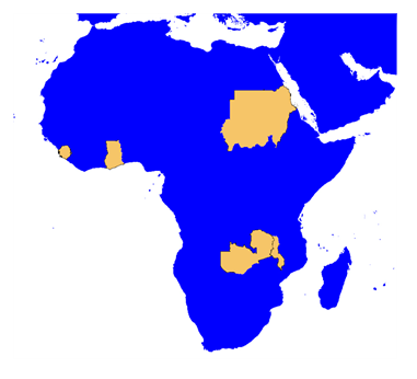
PROJECTS OF AVASYA RESOURCES
The company’s focus is on the discovery and development of Green Energy Metals, Tin, Coltan, Precious &
Base metals, Gemstones and Heavy Minerals deposits over its own Licensed areas in Africa & Asia
The Avasya Resources’ portfolio is
extensive and exhaustive with
commitments towards ONE Mining
Lease and THREE Exploration Licences
for Gold, cumulatively covering an
area of 222 sq.km. ONE Polymetallic
Exploration License for Lithium,
Graphite, Tin, Coltan and REE
covering an area of 75 sq.km. ONE
Exploration License for Graphite
covers an area of 0.9 sq.km. FOUR
Exploration Licences for Gemstones
and Lithium covering an area of 1955
sq.km. ONE Exploration License for
Base metals to cover an area of 380
sq.km and FOUR Exploration Licences
for Heavy Mineral sand over an area of
536 sq.km in different countries in
Africa.
ASR Mining Pvt Ltd was incorporated in 2007 at Hyderabad, India and the Business name has been changed to
Avasya Resources Pvt Ltd in 2016. The Company has country specific wholly owned subsidiaries through ASR
Global Pte Ltd, Singapore
Sudan is Africa's 3rd largest Gold producer as of 2019. Ancient
historical records indicate that gold and iron mining in the country
existed under the kingdom of Meroe and also during the reign of
the kingdom of Nubia, the Pharaonic era, during the Roman
period. The name 'Neb' in the Nubian language means "gold" and
is attributed to the Nuba region. It was also called the "country of
metal" by the British. Artisanal gold mining operations currently
contributing to ~85% of the total national production.
The potential of economic gold deposits in Sudan is high. The pan-
African Ophiolite decorated sutures and greenstone belts in
Sudan, contain over 150 gold occurrences. Three main categories
of these occurrences are recognized; Gold in quartz veins
mesothermal gold deposits, Gold co-precipitated and associated
with massive sulphides and barite, and remobilized gold found in
(oxidation zones) gossans. Tertiary and quaternary, gold placers
are found in the subtropical areas.
Gold Mining Activities cover 14 of the 18 Sudanese states. Over 1 million miners participate in gold mining and
extraction. As of 2015, 12 large scale producing mines and 160 large scale exploration licenses held by Sudanese and
Foreign entrepreneurs. Small scale producing mines are 43 in number and 190 small scale exploration licenses
awarded to local Sudanese. In 2018, about 73.3 million tons of Gold ore was produced.
Block 68A
(Mineral Prospecting License)
This license area covers an area of 300 sq.km awarded to explore & exploit Gold and associated metals.
Located on the Onib - Sol Hamed belt, North of Onib, Red Sea State, Sudan .
Geologically, situated east of the Hamisana shear zone that separates the western gabgaba terrain from the Gebeit and Gerf terranes.
Successful exploration has established Sheared & Altered Gold Bearing rock formations over an area of 2.5 sq. km.
Detailed Exploratory Diamond Core Drilling is in Progress to further establish Satellite deposits
Process of Mining lease is underway.
ZAMBIA, SOUTH CENTRAL AFRICA
POLYMETALLIC (LITHIUM, GRAPHITE, TIN, COLTAN & REE) PROJECT
23570-HQ-LEL (CHIPAZUBA)
(Large Scale Exploration Licence)
This license area is potentially mineralized with Lithium, Flake Graphite, Tin, Coltan, REE and Amethyst over an extent of 72.43 sq km.
Located in the Kalomo and Sinazongwe districts of Southern Province of Zambia and 110 km off Kalomo town, the district capital of Kalomo
Geologically, this area is a Meso-Proterozoic Terrane lying on the Choma-Kalomo Tectonic Block, situated south of the Pan-African Zambezi Belt
Successful exploration has proven an area of 3.0 sq km rich in Tin & Coltan bearing Pegmatites
Active exploration in the LCT pegmatites, REE bearing Carbonatites and Graphite-rich basement area is in progress and expected to be completed within two years.
Mining is the important industry in Zambia with its long history and is
expected to continue so in future. Zambia offers a favorable
economic and political environment for the mining industry to thrive,
thus makes an attractive mining destination.
Zambia is the 7th largest producer of copper with world’s highest
grades. About 70% of the country’s foreign exchange earnings are
from the export of copper alone. Besides copper production, Zambia
produces about 20% of the world’s total production of emeralds.
Several diverse terrains ranging from a stable early Proterozoic
craton to structurally complex "mobile belts" and younger cover rocks
make Zambian geology. This diversity facilitates considerable
exploration potential in the country. The geological complexities and
multiple tectonothermal events evident in Zambia are make the
country's unique geographic location between the massive Kasai
Craton on the west and the Zimbabwe-Kaapvaal ('Kalahari') and
Tanzania cratons on the south and north respectively.
The geological evolution of the country is owing to the inter-cratonic
dislocations and the buttressing effects exerted on these stable
blocks.
Rare Earth Elements (REE) Exploration
Ghana has been producing and exporting Gold for Centuries and is Africa’s 2nd
largest and World’s 10th largest Producer of Gold.
As of December 2013, 13 large scale producing mines, 235 Reconnaissance &
Prospecting licenses have been awarded to Ghanaian and Foreign entrepreneurs.
About 90 Million tons of Gold ore was produced in 2014 and an amount of $13.4
billon was invested in Mining during 1983-2012.
Major Gold Producing are the Ashanti, Asankrangwa and Sefwi-Bibiani Belts.
About 160 Million oz of Gold was estimated in these three belts
AVASYA Resources had incorporated Dharani Mining Limited in 2010. Dharani Mining has two joint ventures and one wholly owned Licenses in SW-Ghana located on the three major producing gold belts.
Ashanti Belt - 115 M. Oz
Asankrangwa Belt - 10 M. Oz
Sefwi Bibiani Belt - 25 M. Oz
This license area consists of both Alluvial Gold bearing gravel and Hard rock Gold over an extent of 15.62 sq km.
Located at the district capital of Wassa Akropong in the Wassa Amenfi East district of the Western Region of Ghana.
Geologically, this area lies on the Ayanfuri-Wassa Akropong Gold sub-belt, it is parallel to the main Ashanti Gold Belt.
Successful exploration has proven 4 sq km of Gold Bearing gravel bed.
Exploration in the Hard rock area is in progress and expected to be completed within two years.
EIA studies are in progress for obtaining EPA permit for Alluvial Gold Mining.
WASSA AKROPONG
(Mining Licence)
This license area consists of both Alluvial Gold bearing gravel and hard rock gold over an extent of 74 sq km.
Located 30 Km NNW of Kumasi and 10km NNW of Offinso the District Capital of Offinso Municipal District of the Ashanti Region of Ghana.
Geologically, this area lies in the Kumasi Basin.
It lies northwest of the Asankrangwa - Manso Nkwanta gold belt & northeast of the Bibiani Gold Belt of Ghana.
Successful exploration has proven 16 sq km of Gold bearing gravel bed.
Exploration in the hard rock area is in progress and expected to be completed within three years.
SAMPRASO
(Prospecting Licence)
WASSA AKROPONG
(Mining Licence)
SAMPRASO
(Prospecting Licence)
Teekyere
(Prospecting Licence)
This license area holds promise for hard rock Gold over an extent of 56.28 sq km.
Located in the Tano-North District of the Brong Ahafo Region of Ghana.
Kumasi-Sunyani highway passes roughly through the middle of the Concession.
Geologically, this area lies on the Sefwi Gold belt. neighbouring deposits are the Ntotoroso zones(A to E), Kenyase, Yamfo, Subenso, Teekyere west, Bosumkese and Mankranho’s areas (I to IV) of Newmont Ghana Gold Limited.
Sustained efforts in exploration have proven presence of Gold in the concession.
Exploration in the Hard rock area is in progress and expected to be completed within four years
ZAMBIA, SOUTH CENTRAL AFRICA
The occurrences of gemstones was first recorded in Zambia
(Luanshya) in 1928 about 94 years ago. Gemstones have shown to be
a potential contributor to the socio-economic growth of Zambia in
the 1970’s after the discovery of emeralds in the Copperbelt
province.
Smallscale mining for aquamarine, tourmaline and red garnet from
granitic-pegmatites in Lundazi area in the Eastern province of
Zambia started in the late 1970’s.
The pegmatites were exploited for mica as early as 1930’s.
Recoveries of 19 tonnes of beryl were recorded in 1955. In 1960 one
pit, the Aries pit, produced between 40 and 50 tonnes of beryl (some
of which are of gem quality), small crystals of excellent amethyst,
rose-quartz, yellow-green chrysoberyl of up to 0.6m, tourmaline and
uranium minerals that include uranophane, torbenite, and
rutherfordite in addition to muscovite production
However, its commercial extraction began in 1980 when it was
classed as small scale mining due to about 20% of its revenue
generation which boosted the country economy.
In the mid 1980’s, Zambia Consolidated Copper Mines limited (ZCCM) opened a number of pits in the Lundazi area
and between 1987 and 1989 about 528,190g of beryl and aquamarine were produced.
23850-HQ-LEL (Chizizi)
(Large Scale Exploration Licence)
This license area is potentially mineralized with Aqua marine, Garnet, Tourmaline, Rose Quartz and Gold over an extent of 762.8 sq km.
Located in the Chama district of Muchinga Province of Zambia and 110 km off Chama town, the district capital of Chama.
Geologically, this area lying on a Eastern part of the Mesoproterozoic Irumide belt.
Pegmatites are widespread and can be broadly classified into two groups based on age.
Older generation of pegmatites (No Gemstones).
The later generation of pegmatites is intrusive into the crystalline Pre-Karoo rocks.
The later Pegmatites divided into Simple and Complex/Zoned (Gemstone Bearing)
Exploration activity is in progress for Zoned pegamtites
23851-HQ-LEL (Songo Hill)
(Large Scale Exploration Licence)
This license area is potentially mineralized with Aqua marine, Garnet, Tourmaline, Rose Quartz and Gold over an extent of 675sq km.
Located in the Chama district of Muchinga Province of Zambia and 100 km off Chama town, the district capital of Chama.
Geologically, this area lying on a Eastern part of the Mesoproterozoic Irumide belt.
Pegmatites are widespread and can be broadly classified into two groups based on age.
Older generation of pegmatites (No Gemstones).
The later generation of pegmatites is intrusive into the crystalline Pre-Karoo rocks.
The later Pegmatites divided into Simple and Complex/Zoned (Gemstone Bearing)
Exploration activity is in progress for Zoned pegamtites
23851-HQ-LEL (Songo Hill)
(Large Scale Exploration Licence)
This license area is potentially mineralized with Aqua marine, Garnet, Tourmaline, Rose Quartz and Gold over an extent of 247.2 sq km.
Located in the Chama district of Muchinga Province and Lundazi district of Eastern Province of Zambia and 52 km off Lundazi town, the district capital of Lundazi.
Geologically, this area lying on a Eastern part of the Mesoproterozoic Irumide belt.
Pegmatites are widespread and can be broadly classified into two groups based on age.
Older generation of pegmatites (No Gemstones).
The later generation of pegmatites is intrusive into the crystalline Pre-Karoo rocks.
The later Pegmatites divided into Simple and Complex/Zoned (Gemstone Bearing)
Exploration activity is in progress for Zoned pegamtites
HEAVY MINERAL SAND PROJECTS
Malawi traditionally, has been considered as an agro-based rather than mineral-based economy because of the
policies that Government pursued since attaining independence in 1964. As a result, there was a lack of mining
culture, little technical capacity and inadequate foreign and local investment which contributed to the slow
development of the industry.
Malawi hosts at least two billion tonnes of mineable heavy mineral sands around the shore of lake Malawi and along
the Shire river. Heavy Mineral sand deposits comprise high density minerals( Specific gravity more than or equivalent
4.2) that occur as disseminated, lenticular (or) layered concentration with sands and most commonly include Ti
minerals, Gold, Zircon, Monazite and Garnet. By far the most important resources in Malawi are the Ti mineral
sands.
EPL 0358/12
(Exclusive Prospecting License)
This license area consists of Heavy Mineral Sands over an extent of 200 sq km. Located along western shores of lake Malawi from the Onaini, Nkhotakota District to Chikhu, Salima District.
Geologically, Constitutes Pleistocene to Recent Sediments .
A quantum of 2,284 meters were auger drilled over 129 sq km area.
Successfully established an area of 22.17 sq km with 6.2% VHM and estimated resources is 5 Mt of Ilmenite, 68 Kt of Rutile, 0.13Mt of Zircon and 0.15 Mt of Garnet.
Detailed exploration is in progress over remain part of the licence area.
SIERRA LEONE, WEST AFRICA
Sierra Leone is endowed with a large resource base. Primary mineral resources are diamonds, Rutile (Titanium
Oxide), Bauxite, Gold, Iron ore plus the recently discovered Oil and Gas deposit on the shores of the country in
Sulima towards the boundary with Liberia. Sierra Leone has a long history of mining, the sector having featured
prominently in the country’s economy since the early 1930s. Diamonds, Rutile, and Bauxite are currently being
mined by major mining companies, after an interruption from 1995 to 2005 due to the civil war.
Rutile was discovered in Sierra Leone in 1954 in the gravels of the Lanti River south of the Gbangbama
region in the southern province. Four groups of deposits are known to be distributed around the country: the
Gbangbama, Sembehun, Rotifunk and the Kambia deposit. Sierra Leone has the largest natural rutile reserve
in the world.
EL 83/2011
(Exploration Licence)
This license area covers an extent of 247.45 sq km awarded for exploring Heavy Mineral Sands.
Located offshore around Cheppu, Bebu villages within the Dema chiefdoms and Kobo, Chongol, Gambo, San, Mange, Gbie, Bongo, Sabi, Basti’s landing, Mania villages within the Sittia chiefdoms and Periwahun, Kakhei, Petowoma, Torma, Baba, Walbai, Vile, Tisana and Kale villages within the Nongoba Bullom chiefdoms and Dibia, Bengani, villages within the Kwamebai Krim chiefdoms in Bonthe District and Taninahun, Gombu, Mani, Mosine villages within the Mono Sakrim chiefdoms and Kasi, Mina villages within the Kpaka chiefdoms in the Pujehun District, Southern Province in the Republican State of Sierra Leone
Geologically Comprises the Bullom group of Quaternary sediments.
Systematic exploration has established the presence of Heavy Mineral bearing sands
EL 84/2011
(Exploration Licence)
This license area covers extent of 85.71 sq km awarded for exploring Heavy Mineral sands.
Located along Coastal plains around Baba Barmot, Baba, Suen Barmot, Mokoni, Sea pot villages within the Ribbi chiefdoms and Ingland, Moyankor, Mogbakoh villages within the Bumpeh chiefdoms and Mai, Rembe, Njabama, Taintain, Yondu Fakai, Mogbagura and Thegbe villages within the Kagboro chiefdoms in Moyamba District, in the Moyamba District, Southern Province and in the Western Area in the Republican State of Sierra Leone.
Geologically covered by Bullom group sediments.
Exploration has proven presence of Heavy Mineral bearing sands
EL 85/2011
(Exploration Licence)
(Vaild upto Nov-2015)
This license area covers an extent of 132.62 sq km awarded for exploring Heavy Mineral Sands.
Located along Coastal plains around Thegbe, Shengebole , Shuen , Katta , Dibia , Shenge , Jetty , Patti , Tisana, Bendu , Mano Wharf , Baoma , Bumpetoke Wharf , Mosamba villages within the Kagboro chiefdoms and Gbapeneh, Mopallah , Mandu , Buehun , Ndepor , Mosorie , Gbanienah Saha villages within the Timdale chiefdoms in the Moyamba District, in the Moyamba District, Southern Province and in the Western Area in the Republican State of Sierra Leone.
About 180 km from Freetown(Capital of Sierra Leone), around 7 hours journey via Rotifunk & Bauya to reach the Shenge Town by 4X4 drive.
Geologically Comprises the Bullom group of Quaternary sediments.
Systematic Exploration involving extensive auger hole drill sampling has established the presence and origin of the Heavy Mineral sands.
Mining is expected to surpass the contribution of agriculture to GDP which is currently at 30 percent. This will be a
gradual process considering that the mineral sector contribution to GDP is currently at 10 percent. Malawi has a
variety of known mineral resources that include uranium, heavy mineral sands, strontianite, rare earth minerals,
phosphate, bauxite, gypsum, vermiculite, precious and semiprecious stones, limestone, dimension stone, silica sand,
sulphides and coal.
There is also potential for discovery of other metallic minerals and high value minerals including gold, platinum group
minerals, and diamonds. Therefore, Government will take deliberate steps to invite both local and foreign investors
to in the sector.
RL 0149/2014
( Reconnaissance license)
This license area consists of Base Metals over an extent of 380 sq km.
Located in Northern parts of District of Chitipa in the northern Malawi region.
License Area bounded on the north by Tanzania, southern & western side by Zambia and on eastern side by the Malawi-based mining company's (M/s Resources Star Limited) Ilomba Hill license area.
Geologically, situated on the North Nyasa Alkaline Province (NNAP).
Reconnaissance survey, has been conducted which has indicated that the area consists of seven nepheline syenite intrusions which are, in varying degrees, affected by the Mozambique Orogenic event.
Exploration is in progress and expected to be completed within four years.


.jpg "10.Tourmaline (Schorl)")


